

- Description
-
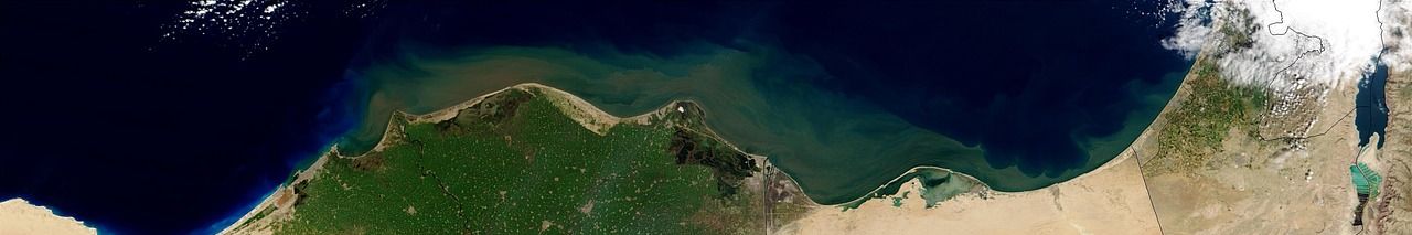
African Geospace is a space technology and data solutions company, pioneering decision-making for development, and climate action.
Mission:
To democratize access to high-resolution satellite data and analytics, empowering individuals and organizations across Africa to make informed decisions that drive sustainable development and innovation.Vision:
To be the leading provider of accessible space technology in Africa, transforming how communities leverage satellite data to address pressing challenges and contribute to a more informed and resilient continent. - Number of employees
- 2 - 10 employees
- Year established
- 2018
- Company website
- https://africangeospace.com
- Categories
- Cloud technologies Software development Machine learning Artificial intelligence Data science
- Industries
- Agriculture Airlines, aviation & aerospace Energy Mining, forestry & fishery Technology
Socials
Recent projects
NewsVIZ: Online Data Visualization Platform
The project aims to develop NewsVIZ, an intuitive online data visualization tool designed for users with no coding experience. The tool will enable users to create interactive charts, maps, and graphs that can be easily embedded in websites or reports. NewsVIZ will support various chart types, including bar charts, line charts, pie charts, scatter plots, and more, offering users a wide range of visualization options. Key features include customization for branding, collaboration capabilities for team projects, and interactivity to enhance user engagement through tooltips, zooming, and filtering. Additionally, the platform will ensure accessibility by allowing charts to be exported in multiple formats and ensuring responsiveness across all devices. The project will also involve developing a pricing model with three categories based on feature packages.
EasyRent: Equipment and Venue Rental Platform
EasyRent aims to revolutionize the event planning industry, with a mobile and web application designed to simplify the process of renting equipment and event venues. The platform will allow users to effortlessly browse, select, and rent a wide variety of equipment and locations for both personal and professional use. The goal is to ensure a seamless user experience from booking to payment and delivery, thereby reducing the hassle and time involved in equipment renting. This project will provide learners with an opportunity to apply their knowledge in web and mobile development, user interface design, and database management to create a functional and user-friendly application. Key features of the platform will include: - User registration and profile management - Search and filter options for equipment and venues - Booking and scheduling system - Secure payment gateway integration - Order tracking and delivery management
African Geospace Promotional Video Creation
African Geospace, a leader in geospatial technology solutions across the African continent, seeks to enhance its online presence through a compelling short corporate video. The goal of this project is to create a 1-3 minute video that effectively communicates the company's mission, values, and innovative solutions. This video will serve as a promotional tool to attract potential clients and partners by showcasing African Geospace's unique offerings and impact in the geospatial industry. The project provides an opportunity for learners to apply their skills in video production, storytelling, and digital marketing. The team will be responsible for conceptualizing the video content, scripting, filming, and editing, ensuring the final product aligns with the company's branding and messaging.
Geospatial Business Engagement Presentation
African Geospace is seeking to enhance its stakeholder engagement by developing a series of compelling business presentation documents. The goal is to effectively communicate the potential applications and benefits of space and geospatial technologies across various sectors, including agriculture, climate change, mining, urban planning, and renewable energy. This project aims to bridge the gap between technical geospatial data and practical business applications, making the information accessible and engaging for stakeholders. By focusing on these sectors, African Geospace intends to highlight the transformative impact of geospatial technologies in addressing industry-specific challenges and opportunities. The project will involve researching sector-specific needs, identifying key geospatial solutions, and crafting tailored presentations that resonate with stakeholders' interests and priorities. - Research the specific needs and challenges of each target sector. - Identify relevant geospatial solutions and applications for each sector. - Develop engaging and informative presentation documents tailored to each sector. - Ensure presentations are visually appealing and easy to understand for non-technical stakeholders.
Latest feedback
Project feedback


Project feedback
Project feedback